Google Earth Introduces Time-Lapse Feature That Lets You Turn Back Time 37 Years
Google Earth Launches New Time-Lapse Feature That Shows Effects of Climate Change Over 37 Years Credit: Google Eart
Google Earth has launched a time-lapse feature to let people scroll through time. It allows users to go back in time with the help of millions of satellite images and see how the world has evolved over 37 years.
The reason for coming up with this technology is to let people see how the world has changed over time. For example, how the glaciers have melted over time due to global warming or the deforestation of the Amazon. According to the company, this is the biggest update in the four years to Google Earth.
Just how Google Maps products are widely used, Google Earth also uses similar technology but instead of using it for public transport and directions, it concentrates more on geology and exploration.
To access the feature of how Alaskan glaciers have melted over the years or forest protection efforts in Brazil, Google Earth has come up with pre-packaged virtual tours where users can access this tool in a web browser.
Google is massively promoting this tool in order to raise climate change awareness and other environmental issues. With the time-lapse feature, users can type and view any location around the globe.
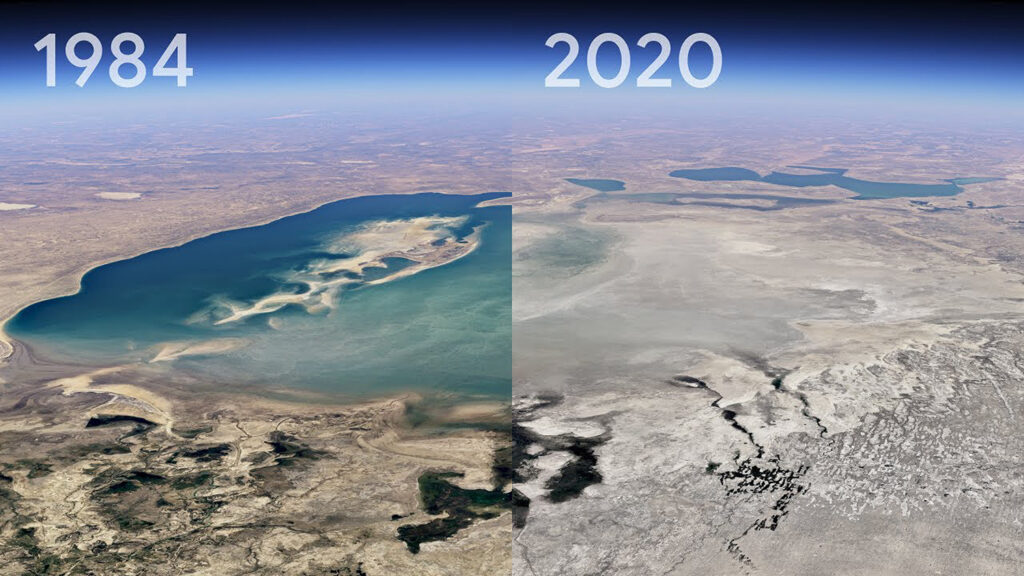
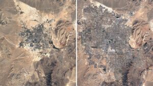
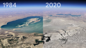
It also shows the rapid extension of towns and cities around the world. For example, the development of Las Vegas or the building of artificial islands in Dubai. The drying of Kazakhstan’s Aral Sea and shifting sands of Cape Cod are the major examples of how the landscape is changing.
According to Google, there is a clear picture of how the planet has changed over time- it not only shows the problems but also the solutions and how beautifully the Earth has unfolded over the decade.
An Earth-sized video
There are 24 million different satellite photos in the new version of Google Earth provided by the US Geological Survey’s Landsat Project, NASA, and the EU’s Copernicus Project.
The animated time-lapse imagery is one giant video mosaic that is made up of individual video tiles, said Google. While at a time users will only see a tiny fraction of the system.
The company said that 24 million images date back to the year 1984 and take upto 20 million gigabytes of storage space.
Quadrillions of pixels together make one single video of 4.4 terapixels in size which is similar to more than half a million 4K ultra-high-resolution videos, said Google.
It took more than 2 million hours of computer time to process the data in a reasonable time frame which is shared among thousands of high-powered machines owned by Google.
There is also a unique feature developed by Google Earth. Any area which is hazy and unclear due to the presence of clouds that is not visible by the satellite- Google Earth can help in removing clouds.
Google says, for at least the next decade it plans to update this time-lapse feature every year.